Aviation Package Features

SiriusXM has a package to suit your needs whether you fly low and slow or high and fast.

Call 1-844-823-0843 or subscribe online.

Base reflectivity is taken from the lowest elevation radar scan (lowest tilt) and typically represents the intensity of precipitation (rain, snow, and mixed precipitation) that is reaching the surface. Most often, it is better for pilots flying below 10,000 feet.

The image is colour-coded to show a complete view of any precipitation. Rain is shown as light green, dark green, yellow, orange and red as intensity increases. Hail, freezing rain and snow are represented with colours from bright pink to blue. Product resolution is 2KM and is available over the Continental US and Southern Canada.

The Lightning feature contains the latitude and longitude of both cloud-to-cloud and cloud-to-ground lightning strikes detected over North America, including the Atlantic and Pacific coasts. It is updated every 2.5 minutes. SiriusXM has recently upgraded its lightning provider to the most accurate and reliable large-scale lightning detection network in the world.

Improvements to the lightning service include:

  • 40% cloud-to-cloud lightning detection improvement
  • 20% lightning strike location accuracy improvement
  • 5% cloud-to-ground lightning detection improvement

The upper air wind grid provides both observed and forecasted upper level winds for each point in the grid. This product covers 3-hour forecast periods through 24 hours, from 5N to 62N and 130W to 65W. Updates every 30 mins.

The upper air temperature grid provides observed and forecasted upper level temperatures for each point in the grid. This product covers 3-hour forecast periods through 24 hours, from 5N to 62N and 130W to 65W. Updates every 30 mins.

Pilot reported information (PIREPs) are observations of icing, turbulence, weather and sky cover fields made by an aircraft in flight. Each PIREP has an associated valid time, latitude, longitude and flight level from where the observations were taken. PIREPs can also contain other information such as tornadoes, funnel clouds, or waterspouts, as well as report the presence of hail or volcanic ash.

Low level wind shear is also often reported by pilots, and typically include the airspeed fluctuations observed. Any fluctuation that is greater than 10kts will be represented as an Urgent PIREP. The geographic coverage area of this product is the rectangle from 62 degrees North latitude, -160 degrees West longitude to 5 degrees North latitude, -50 degrees West longitude. Updates every 15 mins.

The High-Res wind feature displays surface wind conditions. The display can be set to show the current and most recent wind conditions, or to show the forecast up to 48 hours ahead depending on service level. This product covers 5N to 62N, and 130W to 65W. Updates every 20 mins.

The Weather Map displays high (“H”) and low (“L”) pressure systems. Pressure is measured at the center of the system in millibars. The map also indicates cold and warm fronts, the front’s direction of movement, and Isobars (lines of equal pressure). It can be set to show the current conditions, or to show the forecast up to 48 hours ahead. The coverage area is 5N to 62N, and 130W to 65W. Updates every 20 mins.

Radar Coverage indicates which radar sites are available. This is to be used along with radar data to determine where there is radar coverage available. For aviation displays, radar data cannot be output to the display until the corresponding coverage product has been received.

Icing NOWcast depicts the current icing potential, Current Icing Severity (CIS) and Supercooled Large Droplet (SLD) across the continental U.S. SLD information is provided in terms of probability.

This product provides information for the current flight levels:

0 to 3000 ft.
3000 to 6000 ft.
6000 to 9000 ft.
9000 to 12000 ft.
12000 to 15000 ft.
15000 to 18000 ft.
18000 to 21000 ft.
21000 to 24000 ft.

It covers 16N to 54N, and 139W to 58W. Updates every 15 mins.

The Freezing Level product indicates the height at which the air temperature is at or below freezing. Freezing levels are contoured in increments of 100s of feet. This product covers 20N to 62N, and 130W to 65W. Updates every 30 mins.

METARs are the scheduled airport meteorological observations taken at the end of each hour. SPECI is an observation taken at an unscheduled time due to certain conditions such as low visibility, low clouds, frozen precipitation, or thunderstorms.

TAF (Terminal Area Forecast) is the forecasted meteorological condition at an airport for the next 30 hours. In some locations, the projection is only for 24 hours.

IFR (Instrument Flight Rules) includes ceilings less than 1,000 feet AGL and/or visibility 1 mile to less than 3 miles.
LIFR (Low Instrument Flight Rules) includes ceilings below 500 feet AGL and/or visibility less than 1 mile.
VFR (Visual Flight Rules) includes ceilings greater than 3,000 feet AGL and visibility greater than 5 miles.
MVFR (Marginal Visual Flight Rules) includes ceilings between 1,000 to 3,000 feet AGL and/or visibility of 3 to 5 miles.

This CONUS product covers 20N to 51N, and 132W to 65W. The Non-CONUS product covers 05N to 80N, and 179W to 50W. There is overlap between the two products. Updates every 10 mins.

Satellite observation of clouds is represented as temperature data, where colder cloud tops are typically found at higher altitudes. This temperature data is transformed into cloud top height contours. The cloud top product indicates the height of the cloud top in levels with increments of 5000 ft., and covers the continental United States. Updates every 30 mins.

The Graphical Turbulence Guidance product is a model forecast of turbulence severity. The data is provided at flight levels FL180, FL210, FL240, FL270, FL300, FL330, FL360, and FL390 and indicates smooth, light, moderate, and severe turbulence. This product is updated hourly and covers 14N to 59N, and 140W to 56W. Updates every 30 mins.

Surface Visibility Forecasts indicate areas where visibility is expected to be less than ten miles. Visibility is defined in quarter statute mile increments. Good visibility is considered to be ten miles or better. When the estimated visibility drops below ten miles, a contour line appears, separating areas with different levels of visibility. Product coverage is 20N to 62N, and 130W to 65W. Updates every 30 mins.

High-resolution reflectivity shows the maximum intensity of rain, snow, and mixed precipitation for all active radar tilts on each radar site. When compared with Base Reflectivity, the Composite Reflectivity can reveal important storm structure features and intensity trends.

The image is colour-coded to show a complete view of any precipitation. Rain is shown as light green, dark green, yellow, orange and red as intensity increases. Hail, freezing rain and snow are represented with colours from bright pink to blue. Product resolution is 2KM and is available over the Continental US. Updates every 2.5 minutes, twice as fast as ADS-B.

Storm Attributes show information on the severity of storms. The information is recorded by NEXRAD sites wherever there is heavy precipitation. Storm Attributes include the direction and speed of the storm over time, as well as the elevation of the top of the storm. Measured in 100s of feet, the value indicates the height of rain within the storm. The higher the values, the more intense a thunderstorm is likely to be.

Additional information can be displayed, including mesocyclonic activity (MESO, a strong wind vortex), tornado activity (TVS), and the presence or possibility of hail. This feature is available over the Continental United States. Updates every 5 minutes.

Temporary Flight Restriction (TFR) is a restriction on an area of airspace due to the movement of government VIPs, special events, natural disasters, or other unusual events. TFR reports have IDs, effective dates/times, geolocation information (including altitude), as well as the actual text of the restriction. The coverage areas for TFR reports include CONUS, AK, HI, PR, and GUAM. Updates every 5 minutes.

AIRMETS are issued for weather that has been detected or predicted that may affect small, typically General Aviation aircraft. SIGMETS affect the safety of all aircraft.

AIRMETS are issued for the following types of conditions: IFR, Mountain Obscuration, Icing, Turbulence Aloft, Surface Turbulence, or High Surface Winds.

Ceilings less than 1000 feet and/or visibility less than 3 miles affecting over 50% of the area at one time. – Extensive mountain obscuration. – Moderate turbulence. – Sustained surface winds of 30 knots or more at the surface. – Moderate icing. – Freezing levels. SIGMETS are issued when conditions when conditions affecting all aircraft, including heavy ones, have been detected or predicted. SIGMETS are issued for: Icing, Surface Turbulence, Aloft Turbulence, Visibility, Volcanic Eruptions, or Convective Activity.

Both AIRMETS and SIGMETs are considered to be widespread because they must be affecting or be forecast to affect an area of at least 3000 square miles at any one time. However, if the total area to be affected during the forecast period is very large, it could be that only a small portion of this total area would be affected at any one time.

AIRMET Warning Sub Types include: Convective, Icing, Visibility, Surface Turbulence, Aloft Turbulence, Volcanic Eruption, and Unknown. SIGMET Warning Sub Types include: Surface Turbulence, Aloft Turbulence, Icing, Mountain Obscuration, IFR, High Surface Winds, and Unknown.

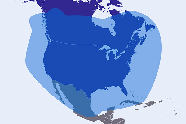
AIRMETs are routinely issued for 6 hour periods beginning at 0245 UTC during Central Daylight Time and at 0145 UTC during Central Standard Time. AIRMETS are also amended as necessary due to changing weather conditions or issuance/cancellation of a SIGMET. SIGMETS are issued for 6 hour periods for conditions associated with hurricanes and 4 hours for all other events. If conditions persist beyond the forecast period, the SIGMET is updated and reissued. Updates to these reports are provided every 10 minutes, and transmitted every 5 minutes. Coverage extends from 5N to 80N and 179W to 50W.

Graphical depiction of radar indicates the maximum height of the NEXRAD reflectivity returns that are 18.5dBZ or higher. The product is used to identify the top of the storm where precipitation is light in intensity. It covers the continental United States. Updates every 5 mins.

The Storm Tracks product provides the historical and forecasted positions of a tropical system, as well as their wind fields. Reports are available over the Atlantic and Eastern Pacific. Updates occur when the National Hurricane Center has identified and is tracking a tropical system. Updates every 5 mins.

SiriusXM satellite radio service provides access to over 300 channels including commercial-free music with exclusive performances and artist dedicated channels; plus coverage of every major sport and dedicated talk channels for all major professional sports, college sports and fantasy; the biggest names in entertainment and talk covering everything from comedy to politics and religion; and breaking news from the most trusted sources. SiriusXM Radio is an optional service with a discount applied automatically when it is added to an Aviation service subscription plan.

(CONUS) – Continental United States weather product with limited or no coverage in Canada.

Get a $300 rebate

With the purchase and subscription activation of an eligible aviation weather receiver.

Help and support

Send a refresh signal

Haven’t flown in a while? We can send a “wake up” signal to your hardware.

Refresh your hardware

Service coverage area

SiriusXM Aviation service is available in the continental United States, southern Canada and coastal regions.

Explore the coverage map.

Need some extra assistance?

Call 1-844-823-0843 or email aviation@siriusxm.ca for personalized help with SiriusXM Aviation. You can also log in to your account if you have account specific issues.

Frequently Asked Questions
How can I temporarily suspend service if I won’t be flying for a while (due to winter weather, maintenance, other)?

You can suspend your SiriusXM Aviation Weather service at no cost for up to 6 months when you are not using it by calling 1-844-823-0843 and asking to suspend.

How often is the SiriusXM Aviation Weather data updated?

SiriusXM Aviation data service elements are updated at multiple rates. Dynamic elements like radar and lightning are updated every 2.5 minutes (twice as fast as ADS-B), while other more stable data elements are updated every 60+ minutes.

Are there any long-term subscription requirements for SiriusXM Aviation Weather?

No. You can subscribe on a month-to-month basis. SiriusXM will bill your credit card monthly in advance, and you may cancel your subscription at any time. We also allow customers to “seasonally suspend” service at no charge for up to 6 months.

How much does SiriusXM Aviation weather cost per month?

There are 4 Subscription Service Plan Tiers ranging from $29.99/month to $99.99/Month, plus any applicable taxes. You can pay monthly, or annually. The SiriusXM Pilot for ForeFlight service plan is $39.99/month plus any applicable taxes.